
Customer rating
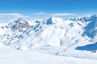
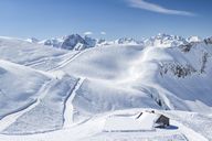
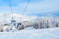
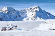
St. François-Longchamp
229 Number of reviews:
96 % Recommendation rate:
Resort
8.6
Ski area
8.9
Piste Map

Information about the ski area
Le Grand Domaine
| Highest point: | 2,514 m |
| Lowest point: | 1,250 m |
| Altitude ski resort: | 1,450 m |
| Lifts in total: | 46 |
| Gondola lift: | 4 |
| Chair lifts: | 14 |
| Tow lifts: | 26 |
| (magic) carpet lifts: | 2 |
| Pistes in total: | 165 km |
|
Pistes:
|
115 km |
|
Pistes:
|
35 km |
|
Pistes:
|
15 km |
| Ski routes: | 7 km |
Weather & Snow report St. François-Longchamp
Are you looking for information about the current snow conditions? Updated weather forecasts for the next few days for St. François-Longchamp can be found here. Often there is also the possibility to view the area via webcam. Further, the active lifts for the ski area of St. François-Longchamp , as well as as the current snow levels on the mountain and in the valley are shown. The diagram also displays a comparison to the previous year's snow levels and supplies an overview for the entire season in St. François-Longchamp .
| Snow depth valley: n/a | Ski lifts open: 0 / 46 |
| Snow depth mountain: n/a | Pistes open (in km): 0 / 165 |
| Last snow fall: n/a | Toboggan run open: n/a |
| Snow condition: n/a | Snow park open: No |
| Winter hiking trails: n/a | Valley run open: No |
Snow report
mountain
valley
Web cams
Weather forecast
|
Today
21/06/26 |
Tomorrow
22/06/26 |
Tu
23/06/26 |
We
24/06/26 |
Th
25/06/26 |
|
|---|---|---|---|---|---|
| 5 days forecast | |||||
| Min. / max. temp. | 10 / 17 °C | 11 / 17 °C | 11 / 16 °C | 11 / 16 °C | 10 / 15 °C |
| Hours of sunshine | 13 h | 14 h | 13 h | 10 h | 12 h |
| Fresh snow | 0 cm | 0 cm | 0 cm | 0 cm | 0 cm |
| Snowfall line | 3,700 m | 3,700 m | 3,700 m | 3,900 m | 3,900 m |
|
Morning |
Midday |
Evening |
Night |
|
|---|---|---|---|---|
| Temperature | 12 °C | 16 °C | 14 °C | 11 °C |
| Wind speed | 0 km/h | 10 km/h | 15 km/h | 10 km/h |
| Fresh snow | 0 cm | 0 cm | 0 cm | 0 cm |
| Snowfall line | 4,000 m | 4,000 m | 3,700 m | 4,100 m |
|
Morning |
Midday |
Evening |
Night |
|
|---|---|---|---|---|
| Temperature | 12 °C | 17 °C | 14 °C | 12 °C |
| Wind speed | 10 km/h | 5 km/h | 10 km/h | 5 km/h |
| Fresh snow | 0 cm | 0 cm | 0 cm | 0 cm |
| Snowfall line | 4,000 m | 4,200 m | 3,800 m | 3,500 m |
|
Morning |
Midday |
Evening |
Night |
|
|---|---|---|---|---|
| Temperature | 13 °C | 16 °C | 14 °C | 12 °C |
| Wind speed | 5 km/h | 10 km/h | 10 km/h | 5 km/h |
| Fresh snow | 0 cm | 0 cm | 0 cm | 0 cm |
| Snowfall line | 4,100 m | 3,600 m | 3,800 m | 4,100 m |
|
Morning |
Midday |
Evening |
Night |
|
|---|---|---|---|---|
| Temperature | 12 °C | 16 °C | 12 °C | 11 °C |
| Wind speed | 5 km/h | 10 km/h | 5 km/h | 5 km/h |
| Fresh snow | 0 cm | 0 cm | 0 cm | 0 cm |
| Snowfall line | 3,700 m | 3,800 m | 3,800 m | 3,800 m |
|
Morning |
Midday |
Evening |
Night |
|
|---|---|---|---|---|
| Temperature | 11 °C | 14 °C | 12 °C | 11 °C |
| Wind speed | 5 km/h | 5 km/h | 0 km/h | 5 km/h |
| Fresh snow | 0 cm | 0 cm | 0 cm | 0 cm |
| Snowfall line | 3,900 m | 3,800 m | 3,900 m | 4,200 m |
|
Today
21/06/26 |
Tomorrow
22/06/26 |
Tu
23/06/26 |
We
24/06/26 |
Th
25/06/26 |
|
|---|---|---|---|---|---|
| 5 days forecast | |||||
| Min. / max. temp. | 13 / 27 °C | 14 / 27 °C | 14 / 27 °C | 14 / 26 °C | 13 / 25 °C |
| Hours of sunshine | 14 h | 14 h | 13 h | 10 h | 12 h |
| Fresh snow | 0 cm | 0 cm | 0 cm | 0 cm | 0 cm |
| Snowfall line | 4,000 m | 4,200 m | 4,100 m | 3,900 m | 3,900 m |
|
Morning |
Midday |
Evening |
Night |
|
|---|---|---|---|---|
| Temperature | 19 °C | 27 °C | 24 °C | 17 °C |
| Wind speed | 5 km/h | 5 km/h | 5 km/h | 0 km/h |
| Fresh snow | 0 cm | 0 cm | 0 cm | 0 cm |
| Snowfall line | 4,000 m | 4,100 m | 4,000 m | 4,100 m |
|
Morning |
Midday |
Evening |
Night |
|
|---|---|---|---|---|
| Temperature | 19 °C | 27 °C | 25 °C | 17 °C |
| Wind speed | 5 km/h | 10 km/h | 5 km/h | 0 km/h |
| Fresh snow | 0 cm | 0 cm | 0 cm | 0 cm |
| Snowfall line | 4,000 m | 4,200 m | 4,200 m | 4,200 m |
|
Morning |
Midday |
Evening |
Night |
|
|---|---|---|---|---|
| Temperature | 20 °C | 26 °C | 24 °C | 17 °C |
| Wind speed | 5 km/h | 10 km/h | 5 km/h | 0 km/h |
| Fresh snow | 0 cm | 0 cm | 0 cm | 0 cm |
| Snowfall line | 4,100 m | 4,100 m | 4,100 m | 4,100 m |
|
Morning |
Midday |
Evening |
Night |
|
|---|---|---|---|---|
| Temperature | 20 °C | 26 °C | 21 °C | 16 °C |
| Wind speed | 5 km/h | 5 km/h | 0 km/h | 0 km/h |
| Fresh snow | 0 cm | 0 cm | 0 cm | 0 cm |
| Snowfall line | 4,000 m | 3,800 m | 3,900 m | 3,900 m |
|
Morning |
Midday |
Evening |
Night |
|
|---|---|---|---|---|
| Temperature | 18 °C | 25 °C | 20 °C | 15 °C |
| Wind speed | 5 km/h | 5 km/h | 5 km/h | 0 km/h |
| Fresh snow | 0 cm | 0 cm | 0 cm | 0 cm |
| Snowfall line | 3,900 m | 3,800 m | 3,900 m | 4,200 m |
Climate
- Hours of sunshine
- Snow fall (cm)
- Snow days
| 2025 | 2026 | ||||||||||
|---|---|---|---|---|---|---|---|---|---|---|---|
| Jun | Jul | Aug | Sep | Oct | Nov | Dec | Jan | Feb | Mar | Apr | May |
| 11 h | 10 h | 9 h | 7 h | 6 h | 4 h | 5 h | 4 h | 4 h | 7 h | 10 h | 8 h |
| 0 | 12 | 3 | 23 | 113 | 167 | 40 | 160 | 276 | 134 | 15 | 79 |
| 0 | 3 | 1 | 4 | 9 | 13 | 8 | 12 | 16 | 11 | 3 | 10 |
Weather data source:© GeoSphere Austria
Snow data source: Skiresort